Pockets of Blue

musings of my mind

Category: Hiking/Backpacking

Trekking to Machu Picchu

Hiya everybody! K and I are back from our five-day trek in the Salkantay region of Peru. It was fabulous and we feel quite fortunate to have booked the tour with a respectable company hiring top-of-the-line chefs and guides.

As you probably know, we don´t typically hire guides for our outdoor adventures. When you´re traveling internationally, though, I think it can be worthwhile to pay somebody else to handle the logistics. This was certainly true for a hike to Machu Picchu, the most popular attraction on the entire continent of South America!

Man, was it ever worth it. The trip involved four bus rides, one train ride, a hotel stay, and three nights of camping. The food was absolutely outstanding — we were offered the entire range of Peruvian classics, from Chicha Morada (a drink made from a native variety of blue corn) to Lomo Saltado (stir-fried beef) to Rocoto Relleno (stuffed roasted red pepper). I could easily dedicate an entire post to the food — each meal had at least three dishes (even breakfast), usually with a soup starter.

We went with Salkantay Trekking, mostly because of their superior website and above-average price (paying a little more for a reputable company seemed like a good idea). After a pre-trip briefing the night before the trip, we headed back to our hostel in Cusco and packed up. They gave us a good-sized duffle bag per person that would be carried by horse or bus between camps (score!) so we didn´t need to go super-light as on a typical backpacking trip. We woke up at 4am in order to be ready to be picked up by 430 — sure enough, Ramiro, our intrepid leader, was there to grab us. We picked up the other four people in our group, two Canadians and two Brits, and set off on a three-hour bus ride to Mollapata, the starting point of our hike. Along the way we stopped at a Restaurante “Turistico” (a sure sign of mediocre food) for a breakfast of eggs, fruit, bread and coffee.

The first day was a relatively easy hike up 8km or so to our first camp, at the end of the road. We had great views of Humantay (5,917m/19,400ft), a rather intimidating-looking glaciated peak to the North. Much of the walk was adjacent to a still-in-use aqueduct built by the Incas several centuries ago. It was a gorgeous path, smooth, flat, and gradually traversing a mountainside with the river raging one thousand feet below. Periodically we would stop to take a break and Ramiro would explain a bit of Inca history or to describe some of the flora along the trail. A native Cusqueñan, he was obviously quite proud of his heritage and eager to share the natural and cultural wonders of the region.
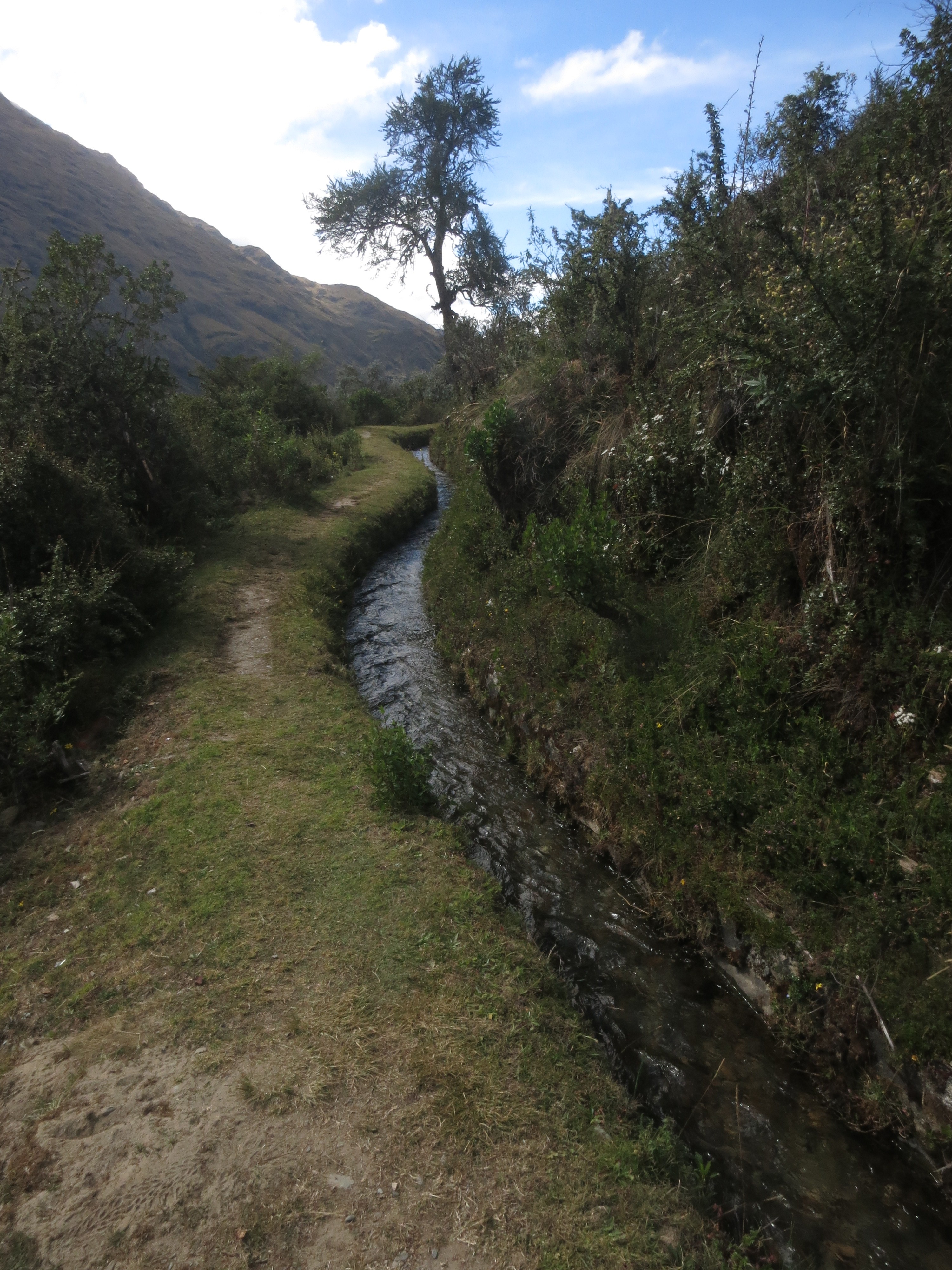
Incan aqueduct

Incan aqueduct

By noon we had reached Soraypampa, a tiny settlement in a wide valley flanked by huge mountains on all sides. The company had set up semi-permanent structures for our tents as well cook tents, helping to keep out the bitter chill of the area, at around 3800m (12,500ft) The six of us saddled up around a table in one of the tents for lunch and were pleasantly surprised with a multi-course meal with plenty of tea to keep us hydrated. Then, we were allowed a few hours’ rest before setting off on a hike up to Humantay Lake to aid with acclimatization. K and I happily napped, and woke up with plenty of time to start hiking.
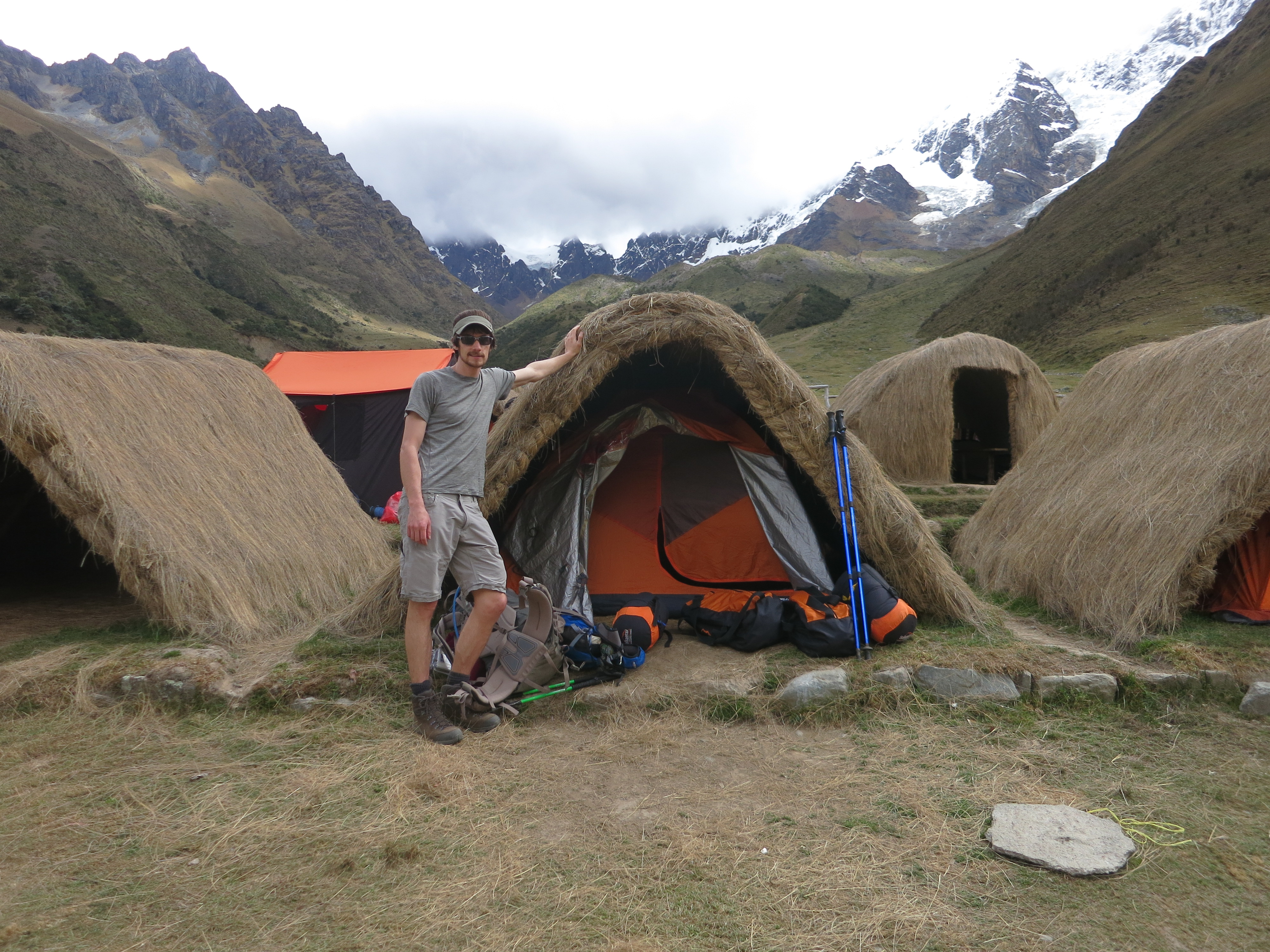
Home sweet home

Home sweet home

The hike was a gradual uphill, and after an hour and a half we crested a hill to the base of the lake, at a lofty 4,270m (14k ft). Humantay towered above us and occasionally sloughed off pieces of its glacier with a roar, creating a dramatic atmosphere. We hung out for a half hour or so before it started to get chilly. The hike down seemed long but went quickly. After a few minutes’ rest we were announced that “happy hour” was ready. This was really just a euphemism for afternoon tea, as we were served various biscuits, cookies, and occasionally something more ornate like a savory pie, along with coca or another herbal tea.

Happy hours were generally the most social times of the trek, as we had a couple of hours on a daily basis to get to know our trekking partners. We talked about travel, national identities, and the usual subjects when people from differing nationalities gather (in our case all anglophones). Typically by seven dinner was served, and we gorged ourselves on traditional peruvian delicacies, especially impressive given the rustic environment. The trek served as an excellent and unexpected introduction to Peruvian cuisine!

That night was quite chilly (the coldest of the trek) and we were back in our tents by 8, as the plan was to rise by pre-dawn to get a head start on a big day, with 22km (14 miles) of hiking.

“Room Service” arrived punctually at 5am — a worker serving coca tea tent-side. We quickly packed up, ambled over to the dining tent for breakfast, ate, and were on the trail by 6:30. The day’s trek would be the hardest of the trip, involving an 800m climb up and over Salkantay pass at over 4600m (15,100ft), then back down the other side, dropping another 1800m to the next campsite. The clouds started to clear up just in time to reveal the massive Salkantay (6300m/21k ft) dominating the Eastern skyline. This time, the glacier was less than a couple kilometers away. We stopped a couple times along the way for snacks and were joined by 100+ tourists (mostly North Americans, seemingly). Luckily the path was quite large, more like a road, so it never seemed too bad. It just certainly wasn’t a wilderness experience.

By 10am or so we reached the pass. Ramiro explained the locals’ tradition of creating an offering for the Apu, or mountain, at the top of each major pass, and we all stoically placed the small stone we had each gathered at the trailhead. He tucked a coca leaf beneath our stones and we all said some words. There were hundreds of cairn-like piles of rock at the pass summit.
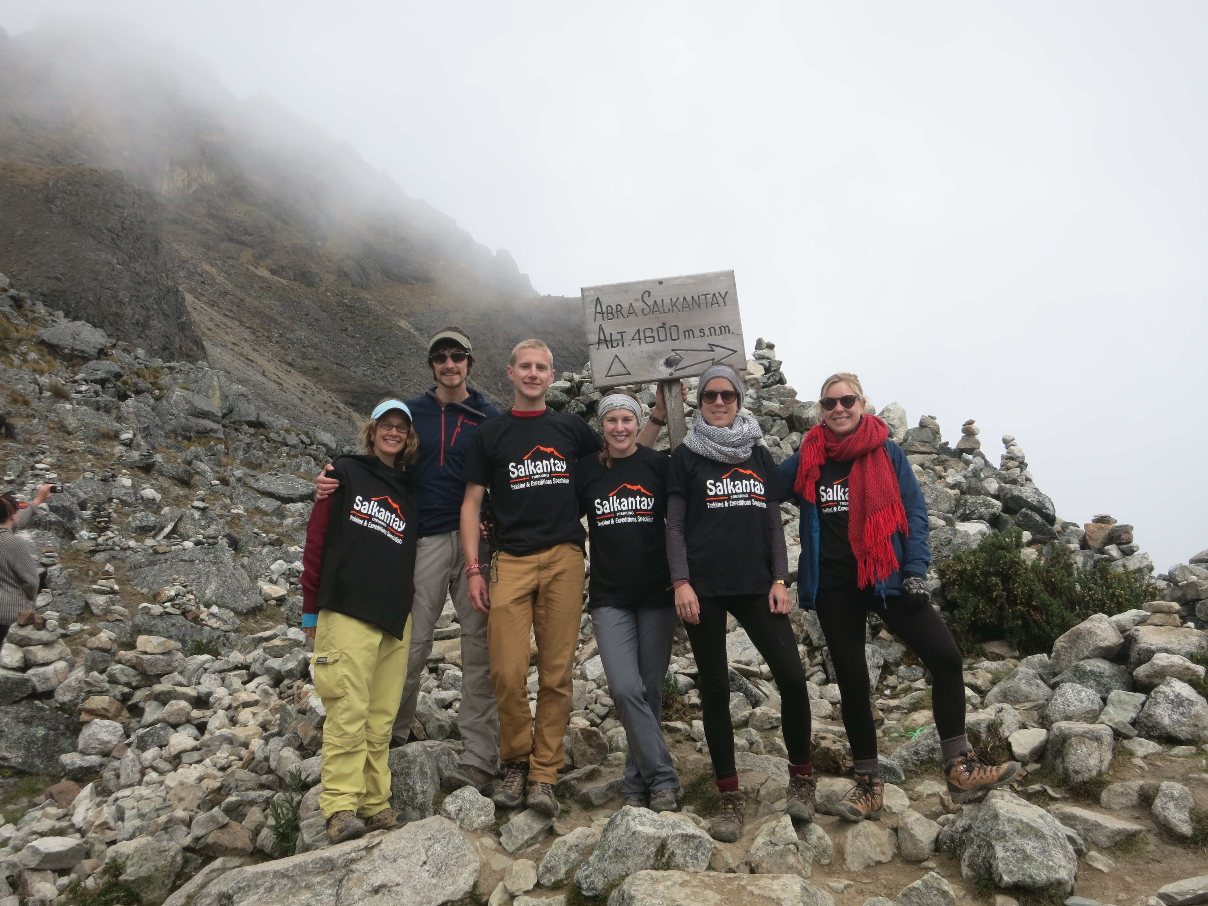
At the Pass!

At the Pass!

With that as our climax, we began the knee-jarring descent, and by noon reached the next town, where we stopped for lunch. It was another delicious meal, but by the end, it was lightly drizzling outside with no signs of slowing down. So we all hunkered down in our raincoats and distracted ourselves with music or an audiobook. For the locals, of course, it was just another few miles in the rain. No biggie. During the hike, our environs almost imperceptibly changed from alpine tundra to jungle. The clouds would flow in and around the lush green mountainsides making for a gorgeous last few hours on an old Inca road. We made it to camp by 5pm or so for a long 11 hours of walking. The evening was similar to the last — hours of cheerful talking around a neverending spread of snacks, dishes and tea. Not too shabby for a quasi-backpacking trip!

Once again, after another tremendous night’s sleep (well, for me anyway) we rose pre-dawn for breakfast. The day’s hike would be another pretty one, starting on a road and then crossing a swollen river to a nice smooth path on the other side. In their usual enterprising fashion, a few of the locals had set up rest areas along the walk to sell snacks, water, and access to a real, flushing toilet . By noon we had reached another trailhead, which began the disjointed part of the trek. We were bussed to the nearest local town for lunch. Pretty much all the tour groups, maybe 60-80 people, were gathered on a second-floor deck for lunch. Our cooks showed off a bit with ornate centerpieces for each plate (Mr. Potatohead carved into a gourd, a shark crafted out of a potato) and we all stuffed ourselves silly. The rest of the day would involve nothing but sitting on a bus or bathing in hot springs, so there was no need to hold back.
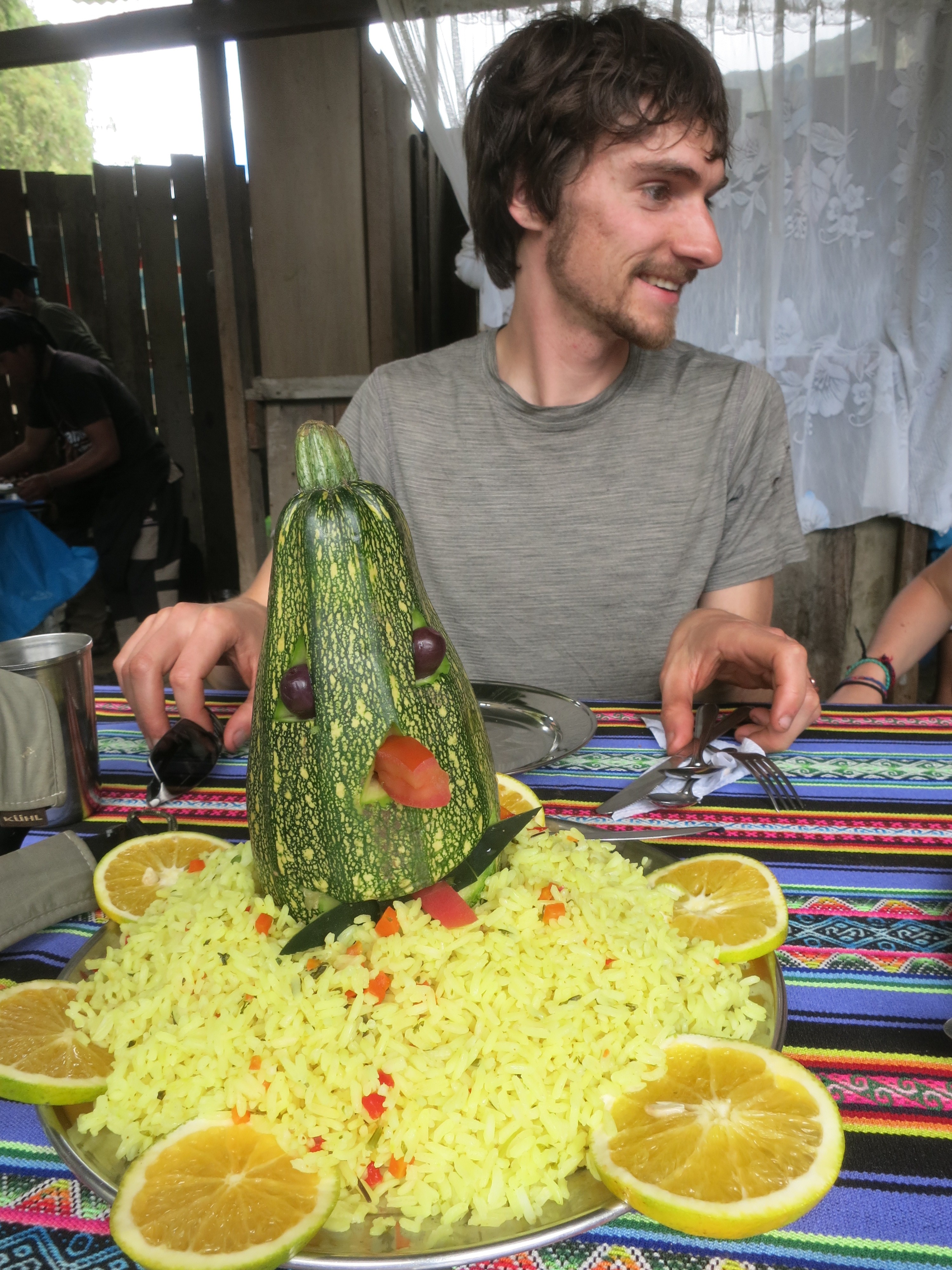
Nom nom

Nom nom

At this point we said farewell to our new British friends, Rachel and Ruby, as they had signed up for the four-day version of the same trek. They were off to Machu Picchu Pueblo that evening while we had an extra day in Santa Teresa (1600m). We enjoyed the natural hot springs with Matt and Ashley and were back to the camp spot by dusk. There we were sold, err, shown, a promotional video for a newly-established zipline operation nearby, which, of course, we had just enough time for the next morning!

The morning broke rainy again, so we delayed the zipline until 730 for the clouds to burn off. For those not in the know, a zipline is basically a thick steel cable suspended over a canyon. One wears a full-body harness and is attached to the line with a pulley, and you zip down the line, hopefully with enough momentum to pull yourself up the last bit at the other end. This one wasn’t too steep, but the longest was over 900m long (half a mile!) making for a nice long ride. It was fun, though my thorough desensitization from heights and exposure may have detracted from the experience. Doing a superman (where the pulley attaches behind you so you can ‘fly’) was pretty sweet though, as it did feel a bit like flying.

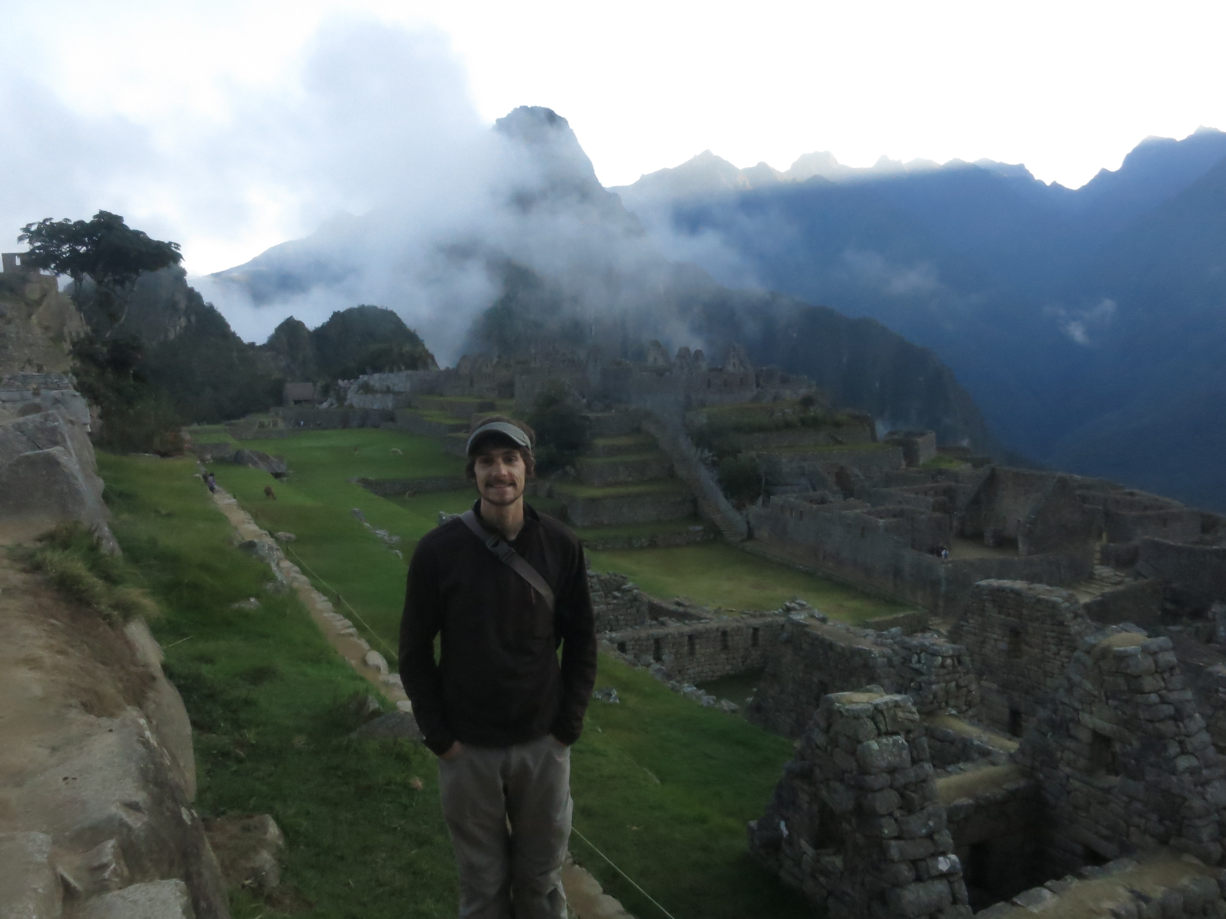
The rest of the day was fairly uneventful — we took a bus to Hidroelectrica, the ‘town’ at the end of the rail line to Machu Picchu Pueblo, and walked the rest of the way along the tracks. At one point we got a great view of the watchman’s hut way up high above the valley. This really piqued our excitement as Machu Picchu promised to be quite the grand finale!

Machu Picchu at last

At last, we woke up at the earliest time yet — 4am, in order to be at the gate for the road by 4:30 so we could be first in line to hike up to the park entrance.  MP is incredibly popular, and most of the tourists take the bus, but if you maintain a fast pace you can beat the crowds to the gate and be some of the first people in.  This really is worth it, as by 11am you’re walking in single file queues to get anywhere.

This is exactly what we did, as Ramiro set a blistering pace up the steep trail.  We made it to the park gates at around 5:45, beating the first bus by 10 minutes or so — very satisfying when you’ve busted your ass walking up 1,800 vertical feet!  Sure enough, our group was the first in.  We headed straight in, and Ramiro gave us ten minutes or so to take it all in before starting the excellent tour.

What a breathtaking place — an ancient city perched on the rib of a mountain, surrounded on all sides by huge mountains, with a thousand foot drop into deep valleys to the North and South.  Clouds swirled around us, occasionally lifting to reveal incredible vistas. We snapped pictures and soaked in the mystery of it all – quiet, majestic yet serene.

Psyched!

Psyched!

Ramiro started off with a brief history of the Incan Empire — Construction of MP began in the last few years before the Spanish invaded, and it was never completed. About 60% of what you currently see there was rebuilt — something I at first disliked, but about which have come around. The original ruins, while certainly authentic, would be much less impressive without the completed walls. Moreover, it is trivially easy to distinguish between the old and new, as the original construction is of a masterful quality.

Thus, we set off for the most interesting structures in the city. I won’t delineate each and every room of the visit, as my memory wouldn’t do them justice, but the tour was superb. Of special interest was the famous Inti Watana stone, serving as an astronomical clock and calendar. We were lucky enough to visit just after sunrise on June 22, the day after the winter solstice, on which the stone cast the second-longest shadow of the year. Later on, Ramiro brought to our attention a large carved rock which almost perfectly matched the silhouette of the mountainous eastern skyline — magnificent!

The tour lasted for a couple hours, hitting the most interesting spots in the city before winding back around to our original point. I was greatly inspired by the surroundings and couldn’t stop taking pictures, which I’ll post when we get back home. We said an emotional farewell to Ramiro, who by that point had assumed a bit of a fatherly figure after shepherding us around for five days, and went back to the entrance area for a break. There we said goodbye to Matt and Ashley, who were off to hike Huayna Picchu (the mountain in the background of all the classic MP pictures), and headed back in to tour the grounds by ourselves. We spent most of the day lounging around the upper terraces, reveling in the spectacular surroundings and general lack of people, before heading back down to the city for another look. Unfortunately, this didn’t last long as the hoards of people became a bit too much, and we reluctantly headed back down in the early afternoon. After another hour of descending we had a rather mediocre lunch in Aguas Calientes before doing a bit of shopping and coffee shop lounging, and were on the train back to civilization by 6pm.

What a great trek! We are enormously fortunate to have had the right combination of good company, a small group, an amazing guide, and excellent food, all for a rather moderate price. I wholeheartedly recommend Salkantay Trekking for your tour if you are headed Machu Picchu way — of course, ask for Ramiro!

Around the World: Part Five

Continued from Part Four

After scarfing down a quick lunch we three set back off on the trail to the highest and Northernmost point of our trek: Everest Base Camp at 5340m (17.5k ft). The trail traverses a rocky moraine with fantastic views of the adjacent Khumbu glacier and the huge Khumbu cirque rimmed by the giants of Nuptse, Everest, Khumbutse and Pumo Ri. Soon we find ourselves winding around on the dirty glacier itself, marveling at the 15m seracs all around us. Before we know it, the jumble of tents seemingly strewn over the glacier appears and we are there.

Base Camp
Everest Base Camp

To be honest, it was a bit anticlimactic: Base Camp isn’t really a set place but wherever each expedition decides to plop a bunch of tents near the foot of the Khumbu Icefall. In this case, three expeditions had just kicked off for the post-monsoon season, from Italy, France, and Korea. The French camp happened to be the closest so we struck up a conversation with a rather entertaining Parisian dude, probably in his late 20s. He mentioned that he had competed in (won?) the Everest Marathon a few years ago, and that they were being sponsored by a French television station and were focusing on recording medical data during the ascent. The expedition was already about a month in and we could spot some climbing Sherpas descending the icefall through the binoculars — pretty cool stuff. After some gabbing we take off back to Gorak Shep, arriving near dusk.

That night is horrendous — I wake up at midnight or so with by far the most splitting headache of my life — it literally feels like my head is wedged in an ever-tightening vise. I pop some more (magic) ibuprofen and grovel to the toilet, expecting to hurl my guts out. It never comes, so I go back to bed and lay in agony til the Vitamin I kicks in and I fade back to dreamland.

We had planned to wake early for the steep slog up to Kala Patthar at 5650 m (18.5k ft), and end up setting out at 7am or so. The timing is excellent — we are behind most of the crowds and have a decent amount of time after sunset to enjoy the views in relative solitude. I wake up feeling fantastic and manage to book it up the hill in under an hour! The Brits meet me up a bit later and we (they) celebrate with Marmite (*vomit*) and crackers. We take pictures of one another and I bask in a heavenly panorama of the entire Khumbu region. I am quite content.

Khumbu Glacier
On the Khumbu Glacier

Later in the day I stumble on Cameron and the posse of Australians he had been traveling with. We agree to meet in Lobuche tomorrow so he has time to go to base camp and Kala Patthar. Tanya, Darren and I depart Gorak Shep in the mid-morning and make our way back down to the nicely low-lying (or not) Lobuche, where we hang out, read and nap for the rest of the day. The next day I meet up with Cam and a couple other Brits, while Tanya and Darren take off on a different path to make their way over Cho La and eventually Gokyo, a supposedly spectacular adjacent valley. The four of us instead descend back to Pheriche and the Himalayan Hotel, where we happen upon Simon and Andy again. I jokingly ask if they ever left the hotel at all and we have a tame evening of cards.

The next day we take eight hours or so (an exceptionally long day by lazy Nepal standards) to get back to Namche Bazaar, where we had pledged to support the fledgling alcoholic merchandising industry as best we can. About twenty beers later (at 11.5k feet mind you) we are drunkenly carrying on in the hotel restaurant about football, politics and god knows what else. Good times.

The next and last day is pretty typical, save the random rendezvous at an Irish Pub in Lukla (wait, what? Yes, an Irish Pub. They even served Guinness.) before we fly out bright and early the next morning. We are the very first flight out and by 9am are checked into a Kathmandu hotel for the next leg of our journey…

This was to be continued, but I unfortunately lost motivation. Contact me and I just may write up the rest…

Around the World: Part Four

Continued from Part Three

A few hours after setting off, the trees start to slowly fade and I find myself in a sub-alpine meadow at about 4000m (13,100ft). I sit and gaze at a massive gash in the mountain across the river, caused by a recent landslide. As I’m daydreaming about climbing Aba Dablam, now shrouded in clouds, some familiar faces crest the hill behind me. It’s Darren and Tanya — somehow they had gotten behind me. We greet each other warmly and set off together towards Pheriche, our next destination at 4200m (13.8kft). Soon we’ve crossed the roaring river again (on a sketchy! plywood bridge). By 1pm or so we’re situated in our hotel of choice, the Himalayan Hotel, which would become by far the most memorable of the trek.

Pheriche
Pheriche

As we sit down for lunch a group of other Brits run into us that Darren recognized from earlier. We celebrate our early arrival with a beer (quite effective at 14k feet!) and a delicious lunch, and decide right then and there to take a rest day the next day; not because of any need for acclimatization but rather due to the (relative) poshness of our environs: a brand-new cozy dining room with seemingly unlimited free reading material (so key!)

At Pheriche there is a semi-permanent camp of the Himalayan Rescue Assocation which happened to be staffed by three Americans while we were there. At three we decide to attend a talk about altitude sickness and it is excellent. The dude had a Gamow Bag, and due to my wearing an altimeter I got to take it for a ride. The doc gave it a pump for a few minutes and I watched my altimeter drop hundreds of meters at a time, until it read 3400m or so. It was pretty cool — a bit claustrophobic but extremely effective for treating altitude sickness.

We spent the next couple of days lounging around the hotel, reading, playing cards and eating. I took a short day trip to Chhukung (4730m/15.5k ft), another beautiful (forgive me if I sound like a broken record, but everything is stunningly beautiful up there) village nestled below the giant South face of Lhotse (8516m/28k ft). Unfortunately I was pretty much in the clouds and couldn’t see much. A nearby hill by the name of Chhukung Ri (5550m) would’ve been by next objective, but I figured there’d be nothing to see up there. Instead I headed back down the valley to Dingboche and Pheriche. Little did I know Cameron was staying in Dingboche when I walked past!

Early the next morning Darren, Tanya and I departed (Simon, one of the others, was feeling the altitude a bit so they stayed behind) for our next destination, Lobuche, at 4910m (16.1k ft). It was going to be a big day elevation-wise, a gain of 700m, so we took it fairly slow. It’s worth mentioning that about Pheriche, the hiking is never difficult or even strenuous, but the altitude starts to make things a bit unpleasant. By lunchtime we arrived, and right around then I started to feel a bit dazed. On my expedition to Mexico a few years ago I didn’t feel any effect from altitude until around 15k feet — this time I was a bit more acclimatized. Regardless, I felt a bit spacey during lunch and felt a moderate headache come on — I decided to pop some Ibuprofen and take a nap.

After waking up I felt awesome — the perfect cure for a hangover! Err, altitude sickness rather. I ambled down for dinner, and there I met a group of Americans in their 50s who were going to attempt Lobuche East, a 6100m trekking peak just west of town. It was especially interesting talking to their Sherpa, a former guide on
Everest, about the nature of commercial expeditions as well as the guiding lifestyle.

Gorak Shep
Gorak Shep’s alpine beach

The next morning we set off again early, excited to make it to the terminal town of the trek, Gorak Shep at 5140m (16.9k ft). We were all feeling pretty good, with slight headaches easily remedied with Ibuprofen (the wonder drug!)
Again we made excellent time and were able to have lunch at our destination. We seemed to have escaped the scourge of the clouds, as well, and finally were able to admire the astounding peaks all around us. The next day’s climb of Kala Pattar, the trek’s terminus, was looking pretty good, not to mention Base Camp…

To be continued

Around the World: Part Three

Continued from Part Two

I step outside our room into the courtyard, turn to go into the kitchen, and am stopped in my tracks. A massive white peak glows in the twilight above. After a cloudy afternoon it is my first good close look at a 6000m peak, presenting itself in dramatic fashion. I snap a picture and smile into the dining room.

Thamserku
Thamserku (6618m) looming over the hotel

A few hours earlier Cam and I set foot on the trail. I was excited to get out of Lukla and finally into some peace and quiet in the countryside. It came quickly and was wonderful. Though this section of the trek is fairly heavily populated, the pace of living quite suits someone who grew up in the woods of Northern New York. We meander through the towns, greeting other trekkers and porters, and eventually make our way to a waterfall by the trail. A short, steep climb brings us to what looks like an amazing hotel. It is perched on a hill with one side looking at the waterfall and the other the fertile river valley below. We immediately get a double room ($3 USD), ditch our packs, and go the dining room to order some food and a gigantic pot of milk tea. There we meet a solo trekker from Switzerland and a British couple. They were headed up, and in a few days I would be joining them.

Dinner was delicious and by 8pm we had passed out, weary from the long day. This would be the start of a pattern — bed near dusk, rise at dawn. A very welcome change from my night owl lifestyle back home. The next morning we headed out early and walked for a few hours before making it to Namche Bazaar (3440m/11,300ft), a beautiful terraced town cut into a bowl in a hillside. Namche is the “Sherpa capital” and largest town in the Khumbu, so we had our choice of dozens of hotels in town. We ended up picking one right in the middle — it had a spectacularly positioned dining room looking out over the gorge to the Southwest, from which we proceeded to gorge ourselves on lunch.

From the start of the trek Cam had been complaining of weariness and coughing, so we decided to take a rest day; mainly for acclimatization but also to give his body a chance to shake out the respiratory infection. We slept in, changed to a “luxury room” (attached shower! wooohoo!), and I set off on a day hike to Thame, a famous Sherpa village four miles up the churning Bhote Kosi Nadi river. It’s a gorgeous walk along a hillside above the river and I chat with a group of cute Sherpa kids on break from school in town. By one pm I’ve made it to Thame (3800m) and have a huge lunch of (unlimited!) Dhaal Bhat, a dish of rice, lentil soup, and vegetable curry. The day is rather cloudy but once in a while the clouds would part to reveal a massive 6000m snow-capped peak a seemingly stone’s throw away.

By the time I make it back to Namche it’s late afternoon and drizzling a bit — we order dinner and I take a (much-needed) shower. Cam is starting to feel better, so we plan to rise early and hike to the next town.


We round a bend in the trail, and something strangely familiar comes into view. In a gap in the clouds two massive mountains appear, and I recognize one instantly: Everest. I stop in awe for a few seconds and snap some pictures — though they’re still 25km away they seem larger than life. It’s a pretty, warm day and I can’t help thinking about what the conditions would be up there..

Thamserku
First glimpse of Everest and Lhotse

A steep drop back down to the Dudh Kosi and back up the other side eventually brings us to Tengboche (3860m/12,660ft). Its famous monastery dominates the town and owns half of the hotels in the village. I know the view is supposed to be incredible, but the afternoon clouds have again robbed any chance of sightseeing. At this point Cameron was feeling pretty rough and was anticipating needing two days to rest. Not looking forward to sitting idly for two days, we decide to split up and meet up at the top of the trek. Luckily, we run into Darren and Tanya (the Brits) again at our hotel at chat it up over dinner. We’re enthused to keep going and I decide to go along with them the next morning.

I wake up excitedly the next morning and peer out the window at a massive cirque of peaks. Rushing outside, I gaze in the splendor of the most superb view of my life. Nothing had ever even come close. Two massive peaks (Thamserku [6618m] and Kangtega [6783m]) dominate, and I mean utterly own, the sky to the Southeast. Their glaciers creep down 2800 vertical meters of their flanks, connecting to the summits less than 6km away. To the North Ama Dablam’s picturesque summit foreshortened the Everest-Lhotse massif just beyond — stunning alpine scenery at 6am.

I pack up after breakfast and bid Cam adieu, setting off on my own. The trail drops down to a thick rhododendron forest and I’m not psyched to be off on my own…


To be continued

Namaste! From Nepal

I’m sitting here in a hotel dining room at 11,500 feet (3440 m) surfing the internet. Ah yes, satellite internet; not cheap at 10 rupees / minute but almost expected in this day in age. Needless to say, this is gonna be a short post.

On the 30th I touched down in Kathmandu, Nepal to a warm rainy evening after a layover in Abu Dhabi, United Aram Emirates. The taxi ride to my hotel was absolutely insane — anyone who’s been in a large city in India would understand…immediately I was put off by the rather destitute environs and by 5am the next morning Cameron and I were off to the airport to escape to the mountains.

So two days ago we landed in Lukla and started our trek — now I’m in Namche Bazaar at the last large village before continuing our ascent to Everest Base Camp (5530 m). Kala Pattar, a lookout point adjacent to Base Camp, is our ultimate goal.

I have been amazed thus far at the magnificent generosity and warmth of the Nepali people. Out here in the mountains there’s next to no worries about crime or even distrust, and I expect this to continue as we get higher.

Oh, and the scenery’s pretty good. Pictures are forthcoming…

Vertical Smiles on Lone Peak

When I first moved out here last year the Wasatch Mountains were my church spires — I would drive by and admire them longingly without really exploring their sanctuaries. Hiking in their vicinity would only fuel an urge for more tactile encounters — the huge rock walls looming in so many crannies and canyons.

One such rock wall stands out; the North Star in a sea of celestial stone. A lighthouse, visible from anywhere in the Wasatch Valley, separating the harem of the North from the sheep to the South — always there keeping watch. It’s called the Lone Peak Cirque, and it holds the single greatest bounty of rock in hundreds of miles of mountains in either direction.

“Did you hear something?” The glow from an oblate moon illuminates Tom’s head crooked to the side.
“Relax, dude, it’s nothing. You’re hearing things.” We continue on the steep trail. Within twenty minutes the crackles of campfires eases our collective unease. Ten minutes later our own blaze adds to the soothing familiarity of the wilderness campground — we are at 8000 feet and a mere three miles from civilization, yet we might as well be in the Yukon. Lulled conversation yields to sleep.

By seven AM we’re psyched again — it’s only a few miles to the Cirque, the weather is beautiful, and we’ve got a full day of stellar climbing ahead. Two thousand vertical feet with 55-pound packs later the psychness wanes. We hike around a ridge and the first two-hundred foot (completely undeveloped) wall of perfect granite emerges. It’s gonna be a great weekend.

“Climb on!” Tom makes the first of many foot jams in a crack and leads into the unknown. We are on the Lowe Route (5.8), the most classic 5.8 in the Wasatch put up by the inimitable George and Jeff Lowe. Tom glides up the perfect hand crack, jamming in cams and feet and hands for 100 feet to a two-piton anchor. It’s on.

The Cirque at Dusk
The Lone Peak Cirque near dusk

The third pitch is phenomenal, a surprisingly well-protected 120′ of face climbing by a finger crack. We top out to a sprawling view of the Provo Valley, flanked by Box Elder Peak and the gigantic Mt. Timpanogos. After a Clif Bar we scramble down, make a couple rappels and hike back to camp.

The main impetus for making the grueling hike up to the cirque was to climb one of the three classic routes on the Summit Wall. It doesn’t get any better than five pitches of perfect rock leading to a 11,000+ foot summit topout, at least in Utah. By 10 am we were at the base of the wall, ready to climb to the summit.

It’s all Vertical Smiles for us as Tom heads off to lead the fourth pitch.
“Are you sure this is the right way?” Tom shouts from a stance at a bolt. We’re six hundred feet above the cirque and quite confused. Maybe it’s the altitude.
“Yeah, just go straight up to the right of that block”
“All I see is roofs!”
“Yeah buddy!” For once I’m happy to be belaying.

The Cirque at Dusk
Tom leading the fourth pitch of Vertical Smile (5.10a II) — the green trapezoid in the incut photo is our position

After a quick hang on a #2 Camalot Tom makes short work of the six-foot horizontal roof. It looms closer and closer as I follow on top-rope. Seven hundred feet off the deck I throw in a hand jam above my head and pull with all my might. What a rad pitch.

We don’t top out right on the summit, but a ten-minute scramble puts us right there on the North Star herself. We bask in the panorama, snap a few shots and head back to Earth.

Takin’ er Easy

Or not. I have been using my still-broken clavicle as an excuse to get back into some activities I’ve been neglecting lately, mainly mountaineering and snowshoeing. From the second weekend after the accident I’ve been out in the mountains in some form on a weekly basis. I started slowly, peddling around Ferguson and Mill Creek Canyons but have been steadily stepping up to longer, more strenuous days in the mountains.

My weeks are still pretty boring since I can’t night ski or climb at the gym, but I have been making up for it each weekend in spades. This past weekend I put in about 20 miles in the mountains with ascents of Mt. Olympus (a walk-up except for a short steep stretch at the end) and a long tour six miles into the backcountry in Mill Creek Canyon. The latter was awesome; the first bona-fide backcountry day in the finest deep powder Utah has to offer. Over the next couple of months I’ll be focusing more and more on the mountaineering aspect as the avalanche danger subsides and my shoulder gets stronger. For now I’m happy going on long tours (with one ski pole..) until I have built up some strength in both arms to use ice tools or do some scrambling.

My shoulder has gotten remarkably stronger over the past few weeks, which has made life much more pleasant and allowed me to resume right-handedness. The climbing will come back with time; otherwise things are pretty much back to normal.

Photos from my weekend jaunts will be up soon…

New Year

Well, the holidays are about over. I’m enjoying my day off much like I enjoyed much of last week: being lazy around the house. Sunday night (the 30th) I returned from NY so it’s back to real life.

New Year’s this year was a bit different. I had originally planned to stick around NY, but then I realized that New Year’s kinda sucks and I didn’t want to take time off just to be able to celebrate it at home. However, almost none of my friends here were back from their holidays so it was looking to be a pretty lame evening. Me being me, I thought, well hell I’ll just go climb a mountain to ring in the New Year. So I did.

At around 8:30 I took off for Mill Creek Canyon to hike Grandeur Peak. Since I still hadn’t purchased a pair of snowshoes I had a couple options: bareboot it with the hopes of an existing tracked out trail or ski it with my touring setup. I was a little sketched out with the snow conditions and it being night at all, so I opted for the former. To be honest, I wasn’t very optimistic about summiting, but a half hour into the hike it was looking pretty good.

Right past the trailhead I got a call from a friend inviting me out to a party for the night. I thought about it briefly and decided to go for the summit solo rather than spend the evening at some random party somewhere. Call me weird but I had my mind set on standing atop a 8300′ peak 4000 feet above my city to ring in 2008.

I was all smiles for the first mile. A perfect snowshoe track made barebooting a breeze, and the trail’s grade only forced me to kick a handful of steps in the snow. Conditions were perfect; there was no wind, it wasn’t too cold, and the sky was a pristine black dotted with stars in all directions. I made good time up to a ridge at about 7500′ and had my first glimpse of the Salt Lake Valley. Since it was only 11pm I figured I had underestimated myself again.
Salt Lake

That is, until I continued on from there. The snowshoe track petered out and I was forced to follow a mountain goat track in my mountaineering boots. A quarter mile later I was panting through hip-deep snow along a mildly corniced ridgeline. The summit loomed a few hundred feet ahead so I plodded on, the hiking trail barely visible amidst the contours of the snow. By 11:30 I had reached the ‘summit,’ just to remember that it was just an intermediary peak and I still had another quarter mile and 600′ to climb. I made a quick decision to continue on, but after trudging through waist-deep snow for about 100 yards I reneged. I would just have to make it back to the ridgeline by midnight.

A little bummed, I plunge-stepped through the snow back to the snowshoe track and made it minutes before midnight. Soon afterwards I heard little ‘pops’ from the valley and saw tiny dots of light, the fireworks being shot off from downtown. Happy New Year Salt Lake!

I motored back down to the trailhead in an hour and kept thinking of all those alpinists over the years, spending nights out halfway up remote, committing mountains in Alaska, Greenland, Pakistan, everywhere. The main difference: Partners. A little companionship and traded encouragement goes a long way towards maintaining a positive mental state and pushing the other to top performance. However, a quality solo adventure can be sublime.

Vacation

So it looks like I’m at a monthly post ratio for this blog.  Guess I don’t have that much to say, but there’s been plenty going on over the past month.  Let’s start from the beginning:

Aug. 25:  Last day of coop, and last day of being a college student.  Feels kinda strange writing that..

Aug. 26:  Moved to my new place.  I lucked out in catching a group of RIT students who were looking to rent a house in the city, around the Monroe Ave/Goodman St. area.  Two of them are my age, and the other a couple years older.  We all get along really well and share quite a few interests (drinking, sports, hiking/climbing, but mainly just drinking).  The house is pretty big, it is three floors with an enormous loft on the third, spacious kitchen, and decks in the front and rear.  We put in a pool table, couple of TVs, stereo system, and fish tank/coffee table, with a kegerator soon to be installed.  The loft is thus far unfurnished, and will probably just be used for parties.  And even though I am further from my job as before, it takes half the time to get there, thanks to I-490.

Aug. 28: Headed home.  Thus began my two-week vacation.  Anyone who knows me well knows that I will take full advantage of any large block of free time available due to its scarcity, and I did.  At first I pretty much just relaxed, but soon grew bored of that.

Aug. 30: Headed to the High Peaks with the aim of conquering Mt. Colden.  Colden was one of those peaks I hadn’t climbed that John had already done, so I figured I’d knock it off in a day trip.  I was up at 5 and summitted just before noon.  Since it was early I cut over to the Van Hovenberg trail to Marcy and took one of the side trails up Tabletop.  Colden was really nice, you can actually see all the way down to the tip of Avalanche Lake 3000 feet below.  It was a beautiful day and I took quite a few pictures.  The total hike was about 8 hours and 15 miles, with ample summit time.  Suki accompanied me the whole way with sheer jubilation. 

Sept. 1-3: moe.down.  The 7th annual festival for Buffalo’s premiere jam band was a blast.  moe. played six rockin’ sets throughout the weekend to a crowd of new age hippies dancing in the mud and rain.  It was awesome.  It was so muddy that they had people lined up outside the parking area to help push people’s cars through the mud to the road.  My front-wheel drive Acura Integra didn’t handle it too well, and by the end of the weekend it resembled one of those Jeeps in their commercials. The elected mayor of moe.down: A sculpture of a squirrel humping a beer can.  Frank Zappa won it last year, and he’s dead, so I don’t know which is stranger.

Sept. 5: Came to the conclusion that I had caught a cold, and attributed it to moe.down.  Big surprise.

Sept. 7: Embarked on my three-day journey in the High Peaks.  I had wanted to do a certain trip for quite some time, and couldn’t get ahold of anyone free that weekend, so I went solo.  That morning I got up at a decent hour, drove to the trailhead at Elk Lake, and was on the trail by one.  It was supposed to be a beautiful few days, and the weather was clear by day, cool by night.  Perfect.  The nine miles into Panther Gorge went pretty quickly, considering the 30 pound pack on my back.  Panther Gorge is a pretty awesome place, it is nestled between three of the four highest peaks in the state, and the lean-to there is new and really nice. 
    The next day I was up at 7 to do a pretty ambitious hike:  The Great Range from Mt. Haystack to Gothics, then over to Sawteeth, then down to Upper Ausable Lake and back around to the Gorge.  The climb up Haystack from Panther Gorge is pretty intense, something like a 1400′ ascent in a mile.  There was some pretty sweet scrambling near the top, especially when you avoid the marked trail for a more fun climb!  I summitted by nine and was surprised to see somebody already up there, a kid from Schenectady.  He was looking to do a Great Range traverse, so it was gonna be a long day for him, even longer than mine.  The view was simply spectacular, easily the best I’ve found in the High Peaks.  And that’s saying something. 
    Next I headed over to Basin.  It was another achingly steep climb, not quite as bad as Haystack but still draining.  I stayed and took some pictures (attempted a self-portrait actually), soaking in the view.  After 20 minutes or so I ventured off for Saddleback.  SaddlebaSaddlebackck has a notoriously steep trail on its western shoulder, and when I hit the bottom of the col between it and Basin, I didn’t see how it was going to be possible to get up.  There’s a ladder at one point to get up a particularly tall cliff, but there’s still a good 50-60 feet of scrambling just before the summit.  It was deliciously fun.  The "trail" is at right.
    Right around the col between Saddleback and Gothics I started worrying about my water supply, since I was just about out and wouldn’t encounter any until I got near Upper Ausable, which was two mountains away.  So I pretty much ran up Gothics (a pretty sweet climb itself) and hung out for 45 minutes attending to a blister.  Afterwards I headed up Sawteeth, which had a surprisingly nice view, especially of Basin, one of new favorite peaks.  I will soon be posting plenty of pictures.
    The hike down Sawteeth was pretty fun because the trail clearly didn’t get much use, and was hardly eroded at all.  I blasted down to the lake and filtered some water (not enough, I would soon discover).  From then on, the hike pretty much sucked.  There is some 1000′ feet of climbing from the lake back up to Panther Gorge, and I was tired and sore and unhappy.  At around six I made it back to camp, exhausted.  I had hiked about 13 miles with over 15,000 feet of elevation change.  Not your typical hike.  After posting trail conditions at Views From the Top I received quite a few incredulous emails from people about the hike.
    The rest of the trip was pretty uneventful, I made it back to Elk Lake in just over 3.5 hours.  Pretty much on cue, as soon as I had finished loading my stuff back into the car, it started raining, and pretty hard at that.  Immaculate timing.

Sept 10: Headed back to the Roc.
Sept 11: Went back to work, this time as an "Independent Contractor" at Soleo.  Since I’ve been back they’ve been keeping me pretty busy, which is also keeping me happy.

Since: Working during the week, partying on the weekends.  Just the way it should be.

© 2024 Pockets of Blue

Theme by Anders NorenUp ↑